What is a floodplain?
A floodplain, which consists of a floodway and a flood fringe, is the land adjacent to a stream or river that experiences occasional or periodic flooding.
I---------------1% Annual Chance Floodplain----------------I
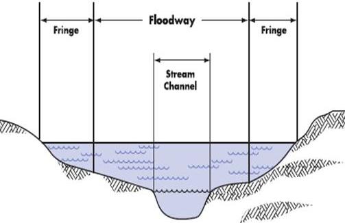
Floodway: stream or river channel and the adjacent area must be reserved in order to pass the base flood (1% annual chance flood) flow without increasing flood depths. The floodway is the most dangerous part of the floodplain. It is associated with moving water.
Flood Fringe: portion of the floodplain that is outside the floodway. It is generally associated with standing, rather than flowing, water.
Many policies and regulations regarding floodplains are based on the 1% annual chance flood (also know as the 100-year flood). This size flood has a 1% chance of occurring in a given year. The 1% annual chance flood does not refer to a flood that only happens once every 100 years. The 1% annual chance flood is also known as the base flood.
Ann Arbor's Floodplains
The Huron River is the largest and most prominent water feature in the City of Ann Arbor. The Huron River originates in Oakland County. Its watershed spans portions of Oakland, Livingston, Washtenaw and Wayne counties. For Ann Arbor residents the river is the primary drinking water source and provides valued recreational opportunities and hydropower.
Within Ann Arbor, five tributary streams have mapped floodplains: Allen, Malletts, Millers, Swift Run, and Traver. The Huron River and tributary floodplains are shown on this map (PDF).
Benefits of Natural Floodplains
Floodplain lands and adjacent waters combine to form a complex, dynamic physical and biological system found nowhere else. When portions of floodplains are preserved in (or restored to) their natural state, they provide many benefits to both human and natural systems. Natural floodplains:
-
Have an important impact on flooding - Flood waters can spread out over a large area in undeveloped floodplains. This reduces flood velocities and provides flood storage to reduce peak flows downstream. Natural floodplains reduce wind and wave impacts and their vegetation stabilizes soils during flooding.
-
Offer several benefits beyond flood reduction - Water quality is improved in areas where natural cover acts as a filter for runoff and overbank flows; sediment loads, and impurities are also minimized. Natural floodplains moderate water temperature, reducing the possibility of adverse impacts on aquatic plants and animals. Floodplains also act as recharge areas for groundwater and reduce the frequency and duration of shallow flooding.
-
Provide wildlife habitat for diverse species of flora and fauna -Some of these species cannot live anywhere else. Floodplains are particularly important as breeding and feeding areas.
Floodplain protection and management in Ann Arbor
The City of Ann Arbor takes a multi-faceted approach to floodplain management, working to protect natural floodplains and to mitigate flooding problems where the floodplain has already been developed. The city:
- Participates in the National Flood Insurance Program (NFIP)
- In 2017 the City joined the Community Rating System (CRS) which rewards communities for going beyond the minimum NFIP requirements with lower flood insurance rates. The City entered the CRS program at Class 7, which resulted in a 15% discount on all flood insurance policies for the citizens of Ann Arbor. On October 1, 2018 the City improved to a Class 6, resulting in a 20% discount.
Regulates floodplains through the Floodplain Management Overlay Zoning District and as a natural feature during the site plan approval process (See the City's
Unified Development Code)
Ensures compliance with the flood resistance construction standards in the Michigan Building Codes
Maintains an extensive park and greenway system in the floodplain along the Huron River, and has numerous other parks in the floodplain areas of the creeks flowing to the Huron River.
The
2022 City of Ann Arbor Hazard Mitigation Plan was approved by FEMA in November 2022. Hazard mitigation means reducing the impact of hazards on people and property. A hazard mitigation plan identifies current and projected natural, man-made and technological hazard risks that may impact Ann Arbor, including flood risks, and works to develop a strategy to reduce these risks. The completed 2022 HMP plan, enables the city to not only increase its resilience to hazards, but maintain its eligibility for state and federal hazard mitigation funding.
Pursues flood mitigation through floodway structure removal, such as the site that now hosts a rain garden and "fish" art installation at the corner of Kingsley and First. The City's Stormwater and Floodplain Programs Coordinator co-presented this City flood mitigation project at the 2016 ASFPM National Conference.
ASFPM 2016 FINAL Presentation - 219 W. Kingsley Flood Mitigation Art.pdf
Stream and Rain Gauges
The United States Geological Service maintains detailed records of river flow, and the City maintains five rain gauges.
Visit the Water Resources Data and Information webpage for information on the four stream gauges and five rain gauges located in Ann Arbor.