Introduction
This is a master's capstone project for the University of Michigan's School for Environment and Sustainability, originally proposed by the Ann Arbor Environmental Commission. Our goal is to create a comprehensive map of all of Ann Arbor's canopy trees with each tree classified by genus. To create this map, we will be using machine learning technology to automatically classify trees found in aerial photos. This requires us to delve into the forests of Ann Arbor and collect "training data" - which entails manually identifying, measuring, and locating trees on the ground. This "ground truth" data will help us ensure that our final map is as accurate and comprehensive as possible.
Such a map will have a variety of uses. These include: identifying native forest fragments as priorities for preservation efforts, locating areas where disturbed native canopies have been displaced by shrubs, and identifying neighborhoods that could benefit from additional tree planting.
Where are we working?
Check out this interactive map to see where we are gathering our ground truth data!
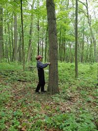
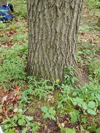
Some photos of our field work
Here are some pictures from our field work so far! The yellow paint at the base of the tree marks it as a tree included in our survey.

Meet the Team
Alyssa Sklar

Alyssa Sklar is a dual-degree M.S. candidate at the University of Michigan’s School for Environment and Sustainability & School of Information. She graduated from DePaul University in 2020 with a B.A. in Geography concentrating in Geographic Information Systems/Geotechnology and minored in Architecture and Urbanism.
Thomas Estabrook

Originally from central Illinois, Thomas Estabrook graduated from Grinnell College with a Bachelor of Arts in Mathematics in 2017. After three years working as an academic coach, he enrolled in the Geospatial Data Science track at SEAS in order to apply his math skills to worthwhile ends.
Christian Schluter

Having spent most of his life on the Massachusetts coast, Christian developed a passion for conservation from an early age. Graduating from Salem State University with a degree in Geography in 2018, he then spent a year in Vermont as a mapping technician, and then a year and a half in South Carolina as an environmental GIS analyst. Deciding that he wanted to further his education, he now studies Geospatial Data Science at the University of Michigan.
Lyndsay Zemanek

A lifelong resident of western Washington, Lyndsay Zemanek has a lot of love and appreciation for forests! In 2019 she graduated from the University of Portland with a B.A. in Mathematics and a desire to apply her analytic skills in an environmental context. This led Lyndsay to the University of Michigan where she currently studies Geospatial Data Science with her fellow teammates.
Acknowledgements
The team would like to thank the following contributors to this project:
- Their advisors Shannon Brines and Jason Tallant
- The City of Ann Arbor Environmental Commission - for proposing this project
- The City of Ann Arbor Office of Sustainability and Innovations - for being so generous by funding our summer fieldwork
- University of Michigan School for Environment and Sustainability
The team would also like to thank everyone involved for their ongoing support, teachings, and enthusiasm for this project!
Please direct any comments or questions to: